1875 OS Map Pz Harbour
treeve

1875 OS Map Pz Harbour

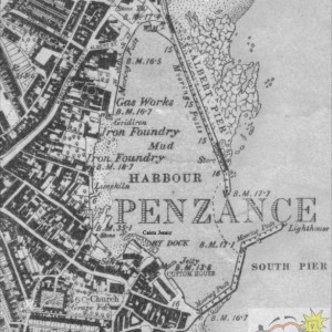
Extract from the 1875 Ordnance Survey Map; The wharf just reaches as far as the Gas Works. Abbey Slip disappeared into the sea, as did Neddy Betty's Lane
originally, before it became Albert Street (Prince Albert had visited the new Albert Pier before it had been completed). Note also the area around Batten's Wharf, which still exists, in part, as the buttressing wall of the Jubilee Pool. My father grew up in Coinagehall Street. To the east of Batten's wharf is the old gun Battery.
Is there a bigger map? seems that it just takes in the edge of the street where I was born, Queen Street - No: 10 to be exact ::15: ::15: ::15:
 
Odd that between Adelaide Street and Mount Street the old Camberwell Street wasn’t named or recorded as a thoroughfare
 
Treeve - I have found an ordinance survey of the Camberwell area dated 1888 on the “British History Online” site and it’s not clearly recorded on that either.
 
I posted and didn't notice your reply - thanks that's very clear. Camberwell Street was very narrow - more like a lane. It's also on the map as Camborne Street, while on the census it is called Camberwell. The Primative Methodist Chapel must have been rebuilt in 1899.
 

Media information

Album
Time past
Added by
treeve
Date added
View count
1,381
Comment count
7
Rating
0.00 star(s) 0 ratings

Share this media

Top Bottom